Претрага
4780 items
-

Landslide types and processes in Serbia
Abolmasov Biljana, Hadži-Niković Gordana. "Landslide types and processes in Serbia" in Croatia-Japan Project “Risk identification and land-use planning for disaster mitigation of landslides and floods in Croatia”, 1st Project Workshop: International experience. Dubrovnik, Croatia, 22-24 November 2010 1, Zagreb, Hrvtaska:Japan International Cooperation Agency (JICA) (2010): 39-39
-
The ICL Adriatic-Balkan Network: Scientific background, opportunities and challenges for regional cooperation
Mihalić Snježana, Arbanas Željko, Mikoš Matjaž, Abolmasov Biljana. "The ICL Adriatic-Balkan Network: Scientific background, opportunities and challenges for regional cooperation" in Proceedings of IPL Symposium, Kyoto, 20th January 2012. International Consortium on Landslides 1 no. 1, Kyoto University, Japan:International Consortium on Landslides (2012): 27-39
-
Landslide Susceptibility Modeling Using Arbitary Polinomal Method
Peševski Igor, Jovanovski Milorad, Abolmasov Biljana. "Landslide Susceptibility Modeling Using Arbitary Polinomal Method" in Abstract book - 2nd Regional Symposium on Landslides in the Adriatic-Balkan Region - 2nd ReSyLAB 2015 1 no. 1, Beograd, Srbija:University of Belgrade, Faculty of Mining and Geology, Belgrade (2015): 93-94
-
Uticaj stenske podloge na kvalitet životne sredine
Srećković-Batoćanin Danica, Jović Vidojko. "Uticaj stenske podloge na kvalitet životne sredine" in Druga ekološka konferencija sa medjunarodnim učešćem/Zbornik radova, Smederevo :lokalni ekološki pokret Smederevo, Univerzitet u Beogradu-Geografski fakultet (2016): 25-35
-
Synchronization of the minimal models of bursting neurons coupled by delayed chemical or electrical synapses
Vasović Nebojša, Burić Nikola, Todorović Kristina, Grozdanović Ines. "Synchronization of the minimal models of bursting neurons coupled by delayed chemical or electrical synapses" in Chinese Physics B 21 no. 1, Kina:Chinese Physics B (2012): 1-8
-
Развој геолошког терминолошког речника ГеолИССТерм
... PetrološkaKlasifikacija StratigrafskiLeksikon Metapodatak 1 0..* +ima 0..1 +ekvivalent 0..* -BiblioRefID -Autor -Naslov -Izdavac -GodinaIzdanja -TipReference -Edicija -Tom_Knjiga -Serija Bibliografija 0..1 0..* 0..1 1..* -NadInstancaID +Naziv -RedniBroj +Sinonimi +Parametri ...
... gIS, geologic Information System, geologic vocabulary, electronic dictionary. INFOtheca, № 1, vol XII, August 201150 rANkA STANkOvIć eT Al. ‒ The DevelOPmeNT OF The geOlISSTerm TermINOlOgIcAl DIcTIONAry 1. Introduction The physical implementation of the geologic Information System of Serbia (geolISS) ...
... vocabulary entry is registered through the Metapodatak (Metadata) class. +OBJECTID ESRI Classes::Object RelacijeTermina +odKoncepta 0..1 0..* +kaKonceptu0..1 0..* GeološkiRečnik -InstancaID -MetazapisID -RepozitorijumID -Naziv -Opis Rečnik -NadInstancaID -RedniBroj -Sinonimi -TerminIzvanUpotr ...Ranka Stanković, Branislav Trivić, Olivera Kitanović, Branislav Blagojević, Velizar Nikolić. "Развој геолошког терминолошког речника ГеолИССТерм" in INFOteka: časopis za informatiku i bibliotekarstvo, Beograd : Zajednica biblioteka univerziteta u Srbiji (2011)
-
Definition of groundwater genesis and circulation conditions of the complex hydrogeological karst system Mlava–Belosavac–Belosavac-2 (eastern Serbia)
Ljiljana Vasić, Saša Milanović, Zoran Stevanović, Laszlo Palcsu. "Definition of groundwater genesis and circulation conditions of the complex hydrogeological karst system Mlava–Belosavac–Belosavac-2 (eastern Serbia)" in Carbonates and Evaporites, Springer Science and Business Media LLC (2020). https://doi.org/10.1007/s13146-020-00550-3
-
Applying terrestrial laser scanning in geotechnical engineering
Bogdanović Snežana, Marjanović Miloš, Abolmasov Biljana, Đurić Uroš, Pejić Marko. "Applying terrestrial laser scanning in geotechnical engineering" in Proceedings of 4th International Symposium of Macedonian Association for Geotechnics 1 no. 1, Struga, FYROM:Faculty of Civil Engineering, Skopje, Republic of Macedonia (2014): 337-342
-
Relationship between the reliability and the lenght of conveyor rubber belt
Tanasijević Miloš, Bugarić Uglješa, Jovančić Predrag, Ignjatović Dragan, Polovina Dragan. "Relationship between the reliability and the lenght of conveyor rubber belt" in 29th Danubia-Adria Symposium on Advances in Experimental Mechanics 1, Beograd :Mašinski fakultet (2012): 274-277
-
Metoda računanja kao izvor greške pri povezivanju i orijentaciji jamskih poligonskih vlakova
Gojković Zoran, Ganić Aleksandar, Milutinović Aleksandar. "Metoda računanja kao izvor greške pri povezivanju i orijentaciji jamskih poligonskih vlakova" in Zbornik radova sa V naučno - stručnog skupa „Podzemna eksploatacija mineralnih sirovina 2017 1 no. 1, Beograd:Univerzitet u Beogradu, Rudarsko-geološki fakultet (2017): 6-11
-
Substitutional and positional disorder in Sr2.87Cu3.13(PO4)4
Karanović Ljiljana, Šutović Sabina, Poleti Dejan, Đorđević Tamara, Pačevski Aleksandar. "Substitutional and positional disorder in Sr2.87Cu3.13(PO4)4" in Acta Crystallographica Section C C66 no. 4, Rosenoerns Alle 1; PO Box 227; Copenhagen V, 1502; Denmark:Blackwell Munksgaard (2010): i42-i44. https://doi.org/10.1107/S0108270110007146
-
Solving Paraffin Deposition Problem in Tubing by Heating Cable Application
Danilović Dušan, Karović-Maričić Vesna, Čokorilo Vojin. "Solving Paraffin Deposition Problem in Tubing by Heating Cable Application" in Thermal Science 10 no. 1, Beograd:Society of Thermal Engineers of Serbia (2010): 247-253
-
Vibration as deciding parameter during revitalization process for replacing the bucket wheel drive
Bošković Saša, Jovančić Predrag, Ignjatović Dragan, Rakićević Branislav, Maneski Taško. "Vibration as deciding parameter during revitalization process for replacing the bucket wheel drive" in Journal of VIBROENGINEERING 17 no. 1, Kaunas, Lithuania:JVE International Ltd. (2015): 24-32
-

Геохемијске карактеристике флотацијског јаловишта рудника Грот (југоисточна Србија)
Božidar Đokić (2012-07-16)У дисертацији су анализиране геохемијске карактеристике флотацијскогјаловишта које се налази на највишој надморској висини у Србији. Јаловиште јенастало преграђивањем узводно од Селишког потока. Географске, геолошке игеоморфолошке карактеристике области у којима је смештено највећим делом суутицали на његову морфологију и морфометрију. Јаловиште чини велики, јужни ијугоисточни плато и велика брана. Делови јаловишта су засебно испитивани, азатим и њихова међусобна интеракција и утицаји на окружење.Прикупљени узорци су испитивани рендгенском дифракциономанализом, скенирајућом електронском микроскопијом, рендгенскомфлуоресцентном спектрометријом, гранулометријском и хемијском анализом.Рендгенском дифракционом анализом ...флотација, јаловиште, скенирајућа електронско-микроскопскаанализа, рендгенска флуоресцентна спектрометрија, Pb-Zn руда,тешки метали, контаминација... <г.д. <г.д. <г.д. 0.1 <г.д. <г.д. <г.д. * 205 559 305 830 <0.03 2 1 0.4 <0,2 0,1 2.7 <1 ** X 1 43 <г.д. - 113 < г.д. 1 <г.д. - <г.д. - - - * 188 650 0.3 642 <0.03 4 1 <0.2 0.1 0.2 ** Ва 2 I 1 16 0.8 8 24 0.3 1 - - - - - - * 8 21 0.03 20 154 <0.01 0.1 <0,2 0.002 0.1 ** ...
... < г.д. <г.д. 2 <г.д. <г.д. <г.д. <г.д. <г.д. * 13 35 0.1 334 926 <0.03 1 1 0.3 <0.2 <0,1 <0.2 <1 ** X <г.д. 54 <г.д. - 117 < г.д. 1 <г.д. - <г.д. - - - * 15 34 0.2 565 <0.03 1 <0.2 0.1 <0.2 ** Ва 3 I 1 3 1 <г.д. 8 0.1 0.1 - - - - - - * 3 6 0.02 14 66 <0,01 0.3 <0,2 0.81 ...
... .... 65 III – 1. ДЕЛОВИ ЈАЛОВИШТА РУДНИКА ГРОТ ...................................................................................................... 65 III – 1. 1. Геохемијске карактеристике великог платоа флот. јаловишта рудника Грот ...................... 70 III – 1. 1. 1. Рендгенска дифракциона ...Božidar Đokić. "Геохемијске карактеристике флотацијског јаловишта рудника Грот (југоисточна Србија)" in Универзитет у Београду, Универзитет у Београду, Рударско-геолошки факултет (2012-07-16)
-
Water in the Alluaudite Type-Compounds: Synthesis, Crystal Structure and Magnetic Properties of Co3(AsO4)0.5+x(HAsO4)2−x(H2AsO4)0.5+x[(H,□)0.5(H2O,H3O)0.5]2x+
In this study, a new cobalt arsenate belonging to the alluaudite supergroup compounds with the general formula of Co3(AsO4)0.5+x(HAsO4)2−x(H2AsO4)0.5+x[(H, )0.5(H2O,H3O)0.5]2x+ (denoted as CoAsAllu) was synthesized under hydrothermal conditions. Its crystal structure was determined by a room-temperature single-crystal X-ray diffraction analysis: space group C2/c, a = 11.6978(8), b = 12.5713(7), c = 6.7705(5) Å, b = 113.255(5)◦, V = 914.76(11) Å3, Z = 2 for As6H8Co6O25. It represents a new member of alluaudite-like protonated arsenates and the first alluaudite-like phase ...супергрупа алуаудита, арсенати прелазних метала, хидротермална синтеза, кристална структура, хидратисани хидрокси-арсенати, стехиометрија, магнетна својстваTamara Đorđević, Ljiljana Karanović, Marko Jagodič, Zvonko Jagličić. "Water in the Alluaudite Type-Compounds: Synthesis, Crystal Structure and Magnetic Properties of Co3(AsO4)0.5+x(HAsO4)2−x(H2AsO4)0.5+x[(H,□)0.5(H2O,H3O)0.5]2x+" in Minerals, MDPI AG (2021). https://doi.org/10.3390/min11121372
-
Геохемијске карактеристике флотацијског јаловишта рудника Грот (југоисточна Србија)
Božidar Đokić (2012-07-16)У дисертацији су анализиране геохемијске карактеристике флотацијскогјаловишта које се налази на највишој надморској висини у Србији. Јаловиште јенастало преграђивањем узводно од Селишког потока. Географске, геолошке игеоморфолошке карактеристике области у којима је смештено највећим делом суутицали на његову морфологију и морфометрију. Јаловиште чини велики, јужни ијугоисточни плато и велика брана. Делови јаловишта су засебно испитивани, азатим и њихова међусобна интеракција и утицаји на окружење.Прикупљени узорци су испитивани рендгенском дифракциономанализом, скенирајућом електронском микроскопијом, рендгенскомфлуоресцентном спектрометријом, гранулометријском и хемијском анализом.Рендгенском дифракционом анализом ...флотација, јаловиште, скенирајућа електронско-микроскопскаанализа, рендгенска флуоресцентна спектрометрија, Pb-Zn руда,тешки метали, контаминација... <г.д. <г.д. <г.д. 0.1 <г.д. <г.д. <г.д. * 205 559 305 830 <0.03 2 1 0.4 <0,2 0,1 2.7 <1 ** X 1 43 <г.д. - 113 < г.д. 1 <г.д. - <г.д. - - - * 188 650 0.3 642 <0.03 4 1 <0.2 0.1 0.2 ** Ва 2 I 1 16 0.8 8 24 0.3 1 - - - - - - * 8 21 0.03 20 154 <0.01 0.1 <0,2 0.002 0.1 ** ...
... < г.д. <г.д. 2 <г.д. <г.д. <г.д. <г.д. <г.д. * 13 35 0.1 334 926 <0.03 1 1 0.3 <0.2 <0,1 <0.2 <1 ** X <г.д. 54 <г.д. - 117 < г.д. 1 <г.д. - <г.д. - - - * 15 34 0.2 565 <0.03 1 <0.2 0.1 <0.2 ** Ва 3 I 1 3 1 <г.д. 8 0.1 0.1 - - - - - - * 3 6 0.02 14 66 <0,01 0.3 <0,2 0.81 ...
... .... 65 III – 1. ДЕЛОВИ ЈАЛОВИШТА РУДНИКА ГРОТ ...................................................................................................... 65 III – 1. 1. Геохемијске карактеристике великог платоа флот. јаловишта рудника Грот ...................... 70 III – 1. 1. 1. Рендгенска дифракциона ...Božidar Đokić. "Геохемијске карактеристике флотацијског јаловишта рудника Грот (југоисточна Србија)" in Универзитет у Београду, Универзитет у Београду, Рударско-геолошки факултет (2012-07-16)
-
Развој геолошког информационог система Републике Србије
Геолошки информациони систем Србије (ГеолИСС) је пројектован, првенствено, са намером ефикасног дигиталног архивирања геолошких и њима сродних података. У овом раду је приказана структура базе података као основа за развој геолошки конципираног ГИС-а. Нови, објектно орјентисани (О-О) начин моделирања омогућио је дефинисање самосталних типова објеката, хијерархијски повезаних кроз тополошке и друге релације, чиме је обезбеђена њихова медјусобна интеракција. Објектно оријентисано моделирање извршено је коришћењем унифицираног језика моделирања (UML) и CASE алата, кроз концептуални и логички ниво. Физички модел ће ...... Lineacija StrukturnaMerenja KompozitneStrukture DeformacioniProcesi TektonskiDogadjaj TektEv olucija_Geneza +output +input 1..* 1.. 1.. 0..* «instanceOf» 0..*1.. Сл. 4. UML схема класа геолошке стуктуре. Fig es . 4. UML scheme of the geological structure class 14. Конгрес Геолога Србије ...
... Опсервација (Сл. 1). cd Realni geološki entiteti Geolog istraziv ac Geol. fenomen. Koncept Opserv acije Teorija - Metodologija +klasifikovanje +Saznavanje +kategorija Kategorizacija +prikupljanje Сл. 1. Основни елементи концептуалног модела ГеолИСС-а. Fig. 1. Basic elements of ...
... својства просторних ентитета (сл. 2). cd Koncept Opservacije Opis GeolISS ProstorniEntitetiGeoloskiRecnik Katalog 0..1 * * * * * 10..*0..1 + validacija + klasifikacija 0..* Сл. 2. UML схема основних – базних класа концептуалног модела ГеолИСС-а. Fig. 2. UML scheme of Basic ...Бранислав Благојевић, Бранислав Тривић, Ненад Бањац, Ранка Станковић, Велизар Николић. "Развој геолошког информационог система Републике Србије" in 14. конгрес геолога Србије и Црне Горе са међународним учешћем, Нови Сад, 18-20. октобар 2005, Cpпско геолошко друштво и Caвeз геолошких друштава Србије и Црне Горе (2005)
-
Permanent GNSS monitoring of landslide Umka
Mileva Samardžić Petrović, Jovan Popović, Uroš Đurić, Biljana Abolmasov, Marko Pejić, Miloš Marjanović (2020)Клизиште Умка је једно од највећих насељених активних клизишта у Србији. Активност клизишта Умка се прати већ више од 85 година, различитим геотехничким и геодетским техникама. Од 2010. године, активност kлизишта се континуирано прати у реалном времену аутоматизованим перманентним системом за праћење базираним на Глобалним навигационим сателитским системима (ГНСС). Поред тога, од 2018. године активност клизишта се додатно прати кинематичким ГНСС одређивањем положаја скупа карактеристичних тачака као и применом UAV фотограметрије. Главни циљ овог рада је приказ резултата опажања три ...... and April 2019, three observation epochs were completed: Epoch 0 - at the end of March 2018, Epoch 1- in late November 2018 and Epoch 3 - in early April 2019. At the same time during the Epoch 1 and Epoch 2, two UAV (Unmanned Aerial Vehicle) photogrammetry epochs were executed as well, but the ...
... y [10] and automated permanent GNSS monitoring [1, 5-9]. Location of Umka landslide. 3. GNSS MONITORING OF UMKA LANDSLIDE For the purpose of Umka landslide monitoring, different geodetic procedures were applied during last 10 years: 1. Automated permanent monitoring of the position change ...
... PROCEEDINGS OF INTERNATIONAL CONFERENCE ON CONTEMPORARY THEORY AND PRACTICE IN CONSTRUCTION XIV PERMANENT GNSS MONITORING OF LANDSLIDE UMKA 1. INTRODUCTION Over the past two decades, driven by the development of geodetic instruments for data acquisition and technology for data processing ...Mileva Samardžić Petrović, Jovan Popović, Uroš Đurić, Biljana Abolmasov, Marko Pejić, Miloš Marjanović. "Permanent GNSS monitoring of landslide Umka" in International Conference on Contemporary Theory and Practice in Construction XIV Stepgrad, University of Banja Luka, Faculty of Architecture, Civil Engineering and Geodesy (2020). https://doi.org/10.7251/STP2014091S
-
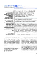
The influence of alkyl polyglucosides (and highly ethoxylated alcohol boosters) on the phase behavior of a water/toluene/technical alkyl polyethoxylate microemulsion system
Marija Ilic, Franz-Hubert Haegel, Vesna Pavelkic, Dragan Zlatanovic, Snezana Nikolic-Mandic, Aleksandar Lolic, Zoran Nedic (2016)The influence of additives (alkyl polyglucoside, Glucopon 600 CS UP and alcohol ethoxylate C18E100) on the behavior of the water/toluene/Lutensol ON 50 (technical oxoalcohol, i-C10E5) microemulsion system as a function of temperature and composition has been investigated. The phase behavior of the microemulsions was determined by vertical sections through the Gibbs phase prism (fish-like phase diagrams). Alkyl polyglucoside shifts the one phase region to lower temperatures compared with water/toluene/Lutensol ON 50 mixtures. This is contrary to the expectation, considering ...микроемулзија, толуен, алкил полиглукозид, оксоалкохол етоксилат, појачивач ефикасности, „fish“ дијаграми... phase denoted 20 (Figure 1). fFigure 1. Schematic “fish cut” phase diagram ofa nonionic microemulsion with equa! water to oil proportions as a function of surfactant concentration. M. ILIĆ efa/: THE INFLUENCE OF ALKYL POLYGLUCOSIDES... Chem. Ind. Chem. Eng. Q. 22 (1) 27–32 (2016) The convenient ...
... surfactant mass fraction, ž, The phase boundaries resemble the shape of a fish. Typically, temperature- -composition phase diagrams obtained for a 1/1 mass ratio of oil and water show a one-phase microemul- sion at relatively high surfactant concentration. At lower surfactant concentration a ...
... ively adding water and oil to the initial water-oil-surf- actant mixture. The samples were prepared by weigh- ing appropriate amounts of components (1:1 ratio of oil to water) on 0.1 mg precision scales in the order surfactant, toluene, water to suppress intermediate formation of liquid crystals ...Marija Ilic, Franz-Hubert Haegel, Vesna Pavelkic, Dragan Zlatanovic, Snezana Nikolic-Mandic, Aleksandar Lolic, Zoran Nedic. "The influence of alkyl polyglucosides (and highly ethoxylated alcohol boosters) on the phase behavior of a water/toluene/technical alkyl polyethoxylate microemulsion system" in Chemical Industry and Chemical Engineering Quarterly, National Library of Serbia (2016). https://doi.org/ 10.2298/CICEQ141105015I
-
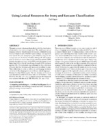
Using Lexical Resources for Irony and Sarcasm Classification
The paper presents a language dependent model for classification of statements into ironic and non-ironic. The model uses various language resources: morphological dictionaries, sentiment lexicon, lexicon of markers and a WordNet based ontology. This approach uses various features: antonymous pairs obtained using the reasoning rules over the Serbian WordNet ontology (R), antonymous pairs in which one member has positive sentiment polarity (PPR), polarity of positive sentiment words (PSP), ordered sequence of sentiment tags (OSA), Part-of-Speech tags of words (POS) ...... can be in the interval [0, 1] where Kalpha = 1 represents complete agreement, and Kalpha = 0 represents complete disagreement. Kalpha can also have a negative value from the [−1, 0) interval caused by sampling mistakes or systemic disagreement. M. Mladenović et al. Figure 1: Architecture of the iro ...
... following way (step 1 in Fig 1). First we manually marked each tweet with a (BCMS) or (not_BCMS) mark. After that we used Serbian Morphological Electronic Dictionaries [22] to automatically tag each word with a mark of belonging to a language _word or not belonging _not (resource A in Fig 1). We introduced ...
... giga’, etc. A complete set of irony markers in lexicon form (resource B in Fig. 1) is a part of the architecture of the suggested model. Ironic tweet classifier (Fig 1) for the purpose of feature construc- tion uses: (1) a set of antonymous pairs (a, z) obtained from the SWN ontology (resource D) a ...Miljana Mladenović, Cvetana Krstev, Jelena Mitrović, Ranka Stanković. "Using Lexical Resources for Irony and Sarcasm Classification" in Proceedings of the 8th Balkan Conference in Informatics (BCI '17), New York, NY, USA, : ACM (2017). https://doi.org/