Претрага
1073 items
-

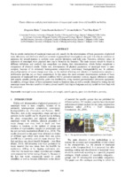
Opšti geotehnički uslovi izgradnje autoputa E-80 Niš – Merdare, Deonica: Niš – Pločnik - II Deo
Rakić Dragoslav, Berisavljević Zoran, Basarić Irena, Lazić Mirko, Stevanović Miloš. "Opšti geotehnički uslovi izgradnje autoputa E-80 Niš – Merdare, Deonica: Niš – Pločnik - II Deo" in Zbornik radova sedmog naučno-stručnog međunarodnog savetovanja - Geotehnički aspekti građevinarstva, Šabac:Savez gradjevinskih inženjera Srbije (2017): 83-92
-
Opšti geotehnički uslovi izgradnje autoputa E-80 Niš – Merdare, Deonica: Niš – Pločnik - I Deo
Rakić Dragoslav, Berisavljević Zoran, Basarić Irena, Lazić Mirko, Stevanović Miloš. "Opšti geotehnički uslovi izgradnje autoputa E-80 Niš – Merdare, Deonica: Niš – Pločnik - I Deo" in Zbornik radova sedmog naučno-stručnog međunarodnog savetovanja - Geotehnički aspekti građevinarstva, Šabac:Savez gradjevinskih inženjera Srbije (2017): 75-82
-
Geotechnical aspects of three dimensional stability analysis of landslides
Ćorić Slobodan, Čaki Laslo, Rakić Dragoslav, Ubiparip Boško, Berisavljević Zoran. "Geotechnical aspects of three dimensional stability analysis of landslides" in Planning, design, construction and renewal in the civil engineering : proceedings / 12 International Scientific Conference INDIS 2012, Novi Sad, 28-30 November 2012, Novi Sad:Faculty of Technical Sciences, Department of Civil Engineering and Geodesy (2012): 361-368
-
Inženjerskogeološki uslovi izgradnje prve deonice autoputa Niš – Merdare“ (Engineering-geological conditions for the construction of the first section of Niš-Merdare highway),
Rakić Dragoslav, Berisavljević Zoran, Basarić Irena, Lazić Mirko, Miloš Stevanović. "Inženjerskogeološki uslovi izgradnje prve deonice autoputa Niš – Merdare“ (Engineering-geological conditions for the construction of the first section of Niš-Merdare highway)," in Treći Srpski kongres o putevima, Beograd: (2018): 12-23
-
The Importance of the Existing Engineering Geological Conditions During the Building Construction on the Terrain Affected by Sliding
Rakić Dragoslav, Berisavljević Zoran, Basarić Irena, Đurić Uroš. "The Importance of the Existing Engineering Geological Conditions During the Building Construction on the Terrain Affected by Sliding" in International IAEG Congres – Engineering Geology for Society and Territory – Applied Geology for Major Engineering Projects 6, Torino, Italy:IAEG - International Association for Engineering Geology and the Environment (2014): 285-289. https://doi.org/10.1007/978-3-319-09060-3.
-
Phase relations and physical indicators of municipal waste from old landfills in Serbia
Due to certain similarities of municipal waste and soil, usually for the determination of basic parameters of physical state, laboratory and field tests which are common in geotechnical investigations are used. It is often to construct an apparatus for special purpose to perform some specific laboratory and field tests. Therefore, different values of indicators of municipal waste physical state can be found in the literature. The basic reasons should be found in different definitions and methods that researchers use ...municipal waste, moisture content, unit weight, specific gravity, grain size distribution, porosityGeneral Computer Science... experimental research to practical applications, CRC Press, Taylor & Francis Group, Torino, taly, 347-354. 1) Rakić D., Basarić I, Berisavljević Z., Berisavljević D. (2016):Geotechnical characteristics of industrial waste slag and sludge from Smederevo steel mill, Serbia. J Knviron Prot Ecol ...
... Unit Relations Unit weight Y kN/m) Y=W/V=(I+w) ·Ya Void ratio e mš/m* e= V /V, = | ___I-n Unit weight W a of solid A kN/m* E i ——— particles Vs 1-n 'Volume water v m*/m* v= V Zw.J0 content -% V Yw Volume gas a m*/m* a _&_ n_w content -% a Saturation g m*/m* S =&=X degree ii -% ii Vp ...
... taken was 1.0 – 12.0 m), values ranged in a wide interval of y = 9.5 — 17.6 108 kN/m, It can be seen that the values are in the domain of possible values of waste unit weight that correspond medium to well compacted waste (Figure 6). unit weighty (kN/n») unit weight y (KN/m*) 15 20 5 0+ E ...Dragoslav R Rakić, Irena G Basarić Ikodinović, Jovana M Janković, Tina D Đurić. "Phase relations and physical indicators of municipal waste from old landfills in Serbia" in Japanese Geotechnical Society Special Publication, The Japanese Geotechnical Society (2021). https://doi.org/10.3208/jgssp.v09.cpeg016
-

Споменица 1991. – 2015. година: 135 година геологије и 70 година рударства на Универзитету у Београду
... источне Србије Палеонтлогија М. Ерцеговац Н. Пантић, Б. Крстић 70. Поломчић М. Душан 19.04.1996. Проблематика формирања изворишта изданских вода у квартарним наслагама Дакијског басена у Србији Хидрогеологија М. Пушић В. Драгишић, З. Стевановић, М. Цветић 71. Маран А. Александра ...
... Finishing: A Sem Study, Archaeometry, 2014. 267. Batalović V., Danilović D., Živković M.: Centrifugal separation of liquid carbon dioxide from natural gas, Hemijska industrija, 2014. 268. Berisavljević D., Berisavljević Z., Čebašek V., Nenad Š.: Characterisation of collapsing loess by seismic dilatometer ...
... а еволуција Фрушке Горе ? М. Марковић И. Ђоковић, Р. Павловић, Б. Ћирић 100. Бабац М. Душан 19.03.1998. Хидрогеолошка истраживања неогенских седимената у средњем делу слива реке Млаве ради решавања водоснабдевања Експл. и заштита подз. вода Др. М. Пушић С. Вујасииновић, В. ...главни и одговорни уредник Душан Поломчић. Споменица 1991. – 2015. година: 135 година геологије и 70 година рударства на Универзитету у Београду, Београд : Универзитет у Београду, Рударско-геолошки факултет, 2016
-
Specifičnosti fundiranja u lesnim naslagama – objekat Poreska uprava Zemun
Anja Dević (2024)U ovom završnom radu prikazani su literaturni podaci koji se odnose na geotehničke karakteristike terena izgrađenih od lesa na primeru šireg istražnog prostora, tzv. Zemunskog lesnog platoa, kao i rezultati detaljnih geotehničkih istraživanja na lokaciji objekta Poreske uprave Zemun. U prvom delu rada prikazani su uslovi nastanka karakteristične makroporozne strukture lesa i njen uticaj na fizičko-mehaničke karakteristike i stabilnost terena izgrađenih od lesa. Na osnovu analize i interpretacije rezultata detaljnih geotehničkih istraživanja na lokaciji objekta Poreske uprave Zemun prikazane su ...... Komisija: 1. Prof. dr Gordana Hadži – Niković, mentor Rudarsko — geološki fakultet, Beograd 2. Doc. dr Dušan Berisavljević, član Rudarsko — geološki fakultet, Beograd 3. Doc. dr Zoran Berisavljević, član Rudarsko — geološki fakultet, Beograd Datum odbrane: Rezime: U ovom završnom radu prikazani ...
... kN/mŠ cs=18 kN/mš (ps=20“ Mv=6500 kN/m? ZT7 = 16.6m • ha=1m Z8 = 18.75me hg=3.3m Z9= 20.4m * Pogrebena zemlja III horizont (pz 3) ye=18 kN/m? ca=19 kN/m? Qg-29 Mv=7000 kN/m? Les IV horizont (I 4) y;=17 kN/m? c;=15 kN/mŠ Qg=20 Mv=7500 kN/m? Student: Anja Dević G68/18 Geotehnički ...
... horizont (pz 1) y=18 kN/mŠ c>=19 kN/m? 2222 Mv=5000 kN/m* Les || horizont (I 2) ya=17 kN/mš ca=15 kN/m9 Qa=20" Mv=5500 kN/m? Z5=11.0m • he=1.4m Z6 = 13.9m • h=4.4m Pogrebena zemlja II horizont (pz 2) y4=18 kN/mŠ ca=17 kN/m 422 Mv=6000 kN/m* Les III horozont (I 3) ys=17 kN/mŠ ...Anja Dević. Specifičnosti fundiranja u lesnim naslagama – objekat Poreska uprava Zemun, 2024
-
Linear-motor plunger pump increases lifting efficiency
Bojan Martinović, Dušan Đekić, Dušan Danilović, Pavel Isaev. "Linear-motor plunger pump increases lifting efficiency" in Oil & Gas Journal (2022)
-
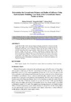
Determining the Groundwater Balance and Radius of Influence Using Hydrodynamic Modeling: the Case Study of the Groundwater Source “Šumice” (Kikinda, Serbia)
A groundwater flow model was developed to simulate groundwater extraction from the public water supply source of the City of Kikinda. The hydrodynamic model includes the municipal groundwater source of Kikinda (Šumice and the Jezero Well), but also an extended area where there are groundwater sources that provide water supply to three factories: (MSK, TM and LŽT - Kikinda). Hydrodynamic modeling, based on the numerical method of finite differences will show the groundwater balance of the sources in the ...... depth of 300 m. Its orientation was north-south and the discretization 100 m × 100 m in three layers. Grid Journal of Sustainable Development of Energy, Water and Environment Systems Year 2015 Volume 3, Issue 3, pp 217-229 222 cells size was refined to 12.5 m × 12.5 m in the area of ...
... Banat Plain, where the highest elevation is 83 m and the lowest 76 m. Water supply is provided to Kikinda by means of 11 wells. The tapped water-bearing horizon is at a depth of about 250 m, formed in Quaternary sands whose thickness is about 50 m. In the vicinity there are also groundwater sources ...
... widths were specified according to a topographic map, with an elevation 0.5 m less than the minimum canal water level, and the thickness of the bottom canal layer of 0.15 m, with a hydraulic conductivity of 1 × 10⁻⁶ m/s. Using the same boundary condition (head-dependent flux boundary condition) ...Dušan Polomčić, Dragoljub Bajić, Jelena Zarić. "Determining the Groundwater Balance and Radius of Influence Using Hydrodynamic Modeling: the Case Study of the Groundwater Source “Šumice” (Kikinda, Serbia)" in Journal of Sustainable Development of Energy, Water and Environment Systems (2015). https://doi.org/10.13044/j.sdewes.2015.03.0017
-
Uticaj proširenja nuklearne elektrane “Pakš” (Mađarska) na resurse podzemnih voda u Vojvodini
Bojan Hajdin, Dušan Polomčić (2016)... podzemnih voda u Vojvodini BOJAN B. HAJDIN, Univerzitet u Beogradu, Stručni rad Rudarsko-geološki fakultet, Beograd UDC:621.311.25:621.039(439) DUŠAN M. POLOMČIĆ, Univerzitet u Beogradu, 556.388:621.039(497.11) Rudarsko-geološki fakultet, Beograd DOI: 10.5937/tehnika1604545H Aktuelna odluka susedne ...
... vršinskih i podzemnih voda i zagađenja tla. Naziv Količina Amonijum hidroksid 1 m 3 Hidrazin 3 t Vodonik 13 m 3 Azotna kiselina 4 m 3 Sumporna kiselina 7 m 3 Hlorovodonična kiselina 53 m 3 Natrijum hidroksid 40 m 3 Bor 6 t Dizel-gorivo 2600 t Transformatorsko ulje 370 t po bloku B. HAJDIN ...
... podzemnih voda u Vojvodini Bojan Hajdin, Dušan Polomčić Дигитални репозиторијум Рударско-геолошког факултета Универзитета у Београду [ДР РГФ] Uticaj proširenja nuklearne elektrane “Pakš” (Mađarska) na resurse podzemnih voda u Vojvodini | Bojan Hajdin, Dušan Polomčić | Tehnika | 2016 | 66 | 5 10 ...Bojan Hajdin, Dušan Polomčić. "Uticaj proširenja nuklearne elektrane “Pakš” (Mađarska) na resurse podzemnih voda u Vojvodini" in Tehnika 66 no. 5, Beograd : Savez inženjera i tehničara (2016): 777-786. https://doi.org/10.5937/tehnika1604545H
-
Ecological apect of sustainable development of the municipality of Lapovo
Petrović Rastko, Polomčić Dušan (2011)Petrović Rastko, Polomčić Dušan. "Ecological apect of sustainable development of the municipality of Lapovo" in Proceedings / IWA Specialist Groundwater Conference, 08-10 September 2011, Beograd:Institute for the Development of Water Resources Jaroslav Černi (2011): 185-192
-
Recalibration of the hydrodynamic model for lignite deposit Drmno in the period od 2015,
Поломчић Душан, Здравковић Ј., Војнић М., Димитријевић Бојан. "Recalibration of the hydrodynamic model for lignite deposit Drmno in the period od 2015," in Зборник радова 8. Међународне конференције УГАЉ 2017, Београд, Србија:Југословенски комитет за површинску експлоатацију (2017): 341-350
-
Mitigating hydrate formation in onshore gas wells: A case study on optimization techniques and prevention
Gas wells, particularly those situated onshore, play a vital role in the global energy sector by supplying a significant portion of natural gas. However, operational challenges, notably gas hydrate formation, pose substantial issues, leading to complications such as flowline blockages and unexpected well shutdowns. Gas hydrates, crystalline structures resembling ice, ...Gas Well, Gas Hydrate Formation, Well Modeling, Well Performance Optimization, Choke Position Adjustments, Methanol InjectionMilica Ješić, Bojan Martinović, Stefan Stančić, Miroslav Crnogorac, Dušan Danilović. "Mitigating hydrate formation in onshore gas wells: A case study on optimization techniques and prevention" in Underground Mining Engineering, Beograd : Rudarsko-geološki fakultet (2023)
-
Stanje i perspektivnost vodosnabdevanja Obrenovca i naselja opštine posle poplava, 2014. godine
Obrenovac i okolna naselja su tokom 2014. godine zbog poplava u Srbiji pretpeli veliku materijalnu štetu, a pored brojnih privrednih preduzeća ozbiljno je bio ugrožen i sistem vodosnabdevanja. Izvorište „Vić bare“ za vodosnabdevanje grada u selu Zabrežje, na Savi, u potpunosti je potopljeno, a vodovodna mreža, u pojedinim delovima već veoma stara, dodatno je oštećena. Poslednjih nekoliko decenija kao glavni razlozi za probleme u vodosnabdevanju Obrenovca isticane su nedovoljne rezerve podzemnih voda na izvorištu. Novijim istraživanjima utvrđene su rezerve ...... godine BOJAN B. HAJDIN, Univerzitet u Beogradu, Stručni rad Rudarsko-geološki fakultet, Beograd UDC: 628.1:504.5(497.11)"2014" DUŠAN M. POLOMČIĆ, Univerzitet u Beogradu, DOI: 10.5937/tehnika1705675H Rudarsko-geološki fakultet, Beograd DRAGOLJUB I. BAJIĆ, Univerzitet ...
... 2014. godine Bojan Hajdin, Dušan Polomčić, Dragoljub Bajić Дигитални репозиторијум Рударско-геолошког факултета Универзитета у Београду [ДР РГФ] Stanje i perspektivnost vodosnabdevanja Obrenovca i naselja opštine posle poplava, 2014. godine | Bojan Hajdin, Dušan Polomčić, Dragoljub Bajić | Tehnika ...
... bunara ostvarena je depresija od 4,57 m (2013), odnosno 4.20 m (2016). Tokom poplavne go- dine, vodostaj Save u septembru mesecu bio je viši za oko 3.5 m u odnosu na 2013. i 2016. godinu. Statički nivoi podzemnih voda u bunarima bili su viši za oko 2.50 m. Crpenjem tokom testiranja bunara na ...Bojan Hajdin, Dušan Polomčić, Dragoljub Bajić. "Stanje i perspektivnost vodosnabdevanja Obrenovca i naselja opštine posle poplava, 2014. godine" in Tehnika, Beograd : Savez inženjera i tehničara Srbije (2017). https://doi.org/10.5937/tehnika1705675H
-
Long-term planning methodology for improving wood biomass utilization
The insufficiently developed forest management system is often followed by undeveloped forest resources supply chain and insufficient institutional support. These cause inefficient usage of fuel-wood as well as huge amounts of unused forest residues. In order to achieve optimal and long-term sustainable utilisation of biomass, an original methodology based on the interaction of mathematical optimization and backcasting approach has been developed. Mathematical optimization is used for both generation and consideration of techno-economic parameters of the forest biomass supply chain. ...Vladimir Vukašinović, Dušan Gordić, Marija Živković, Davor Koncalović, Dubravka Živković. "Long-term planning methodology for improving wood biomass utilization" in Energy, Elsevier BV (2019). https://doi.org/10.1016/j.energy.2019.03.105
-
Hydrographic and hydrological characterization of the Vodenička and Rosomačka rivers
Vesna Ristić Vakanjac, Marina Čokorilo Ilić, Dušan Polomčić, Dragoljub Bajić, Jelena Ratković (2017)The Visočica River rises in Bulgaria, on the Berovo Mountain. Its course in Bulgaria is 16.7 km long. It enters Serbia near the village of Donji Krivodol. Up to the village of Pakleštica, or the beginning of Lake Zavoj, its right-bank tributaries are the Krivodolštica, the Vodenička, the Rosomačka and the Dojkinačka. There are no left-bank tributaries. Among the tributaries, water levels and discharges are gauged only on the Dojkinačka River. The Vodenička had also been gauged but only ...... границом и то од Бегове куле (1668 м н. в.) на исток и југоисток преко Мучибабе (1719 м н. в.), Големог гувна (1580 м н. в.), Аџијине корије (1716 м н. в.), затим преко врхова са котама 1622 м н. в., 1613 м н. в., 1609 м н. в., 1423 м н. в., до врха са котом 1368 м н. в. код Равништа, где напушта државну ...
... гувна (955 м н. в.), Росомачког врха (1236 м н. в.), Игиног вртопа (1276 м н. в.), Чуке (1310 м н. в.), Тупанца (1602 м н. в.), а затим преко Штављака излази на државну границу између Србије и Бугарске код врха Добро јутро. Вододелница даље прати државну границу до Бегове куле (1658 м н. в.). Код ...
... генералним правцем на југ одвајајући слив Росомачке реке од Воденичке и то преко врха Црнак (1592 м н. в.), затим Мешковог рида (1351 м н. в.), Сенокошке чуке (1328 м н. в.), Љиљка (1326 м н. в.), Градишта (1191 м н. в.) па све до Славиње, где је и ушће Росомачке реке у реку Височицу. Облик слива је издуженог ...Vesna Ristić Vakanjac, Marina Čokorilo Ilić, Dušan Polomčić, Dragoljub Bajić, Jelena Ratković. "Hydrographic and hydrological characterization of the Vodenička and Rosomačka rivers" in Pirotski zbornik, Pirot : Narodna biblioteka Pirot (2017). https://doi.org/10.5937/pirotzbor1742001R
-
Groundwater resources for drinking water supply in Serbia´s Southeast Pannonian basin
Dušan Polomčić, Bojan Hajdin, Marina Ćuk, Petar Papić, Zoran Stevanović. "Groundwater resources for drinking water supply in Serbia´s Southeast Pannonian basin" in Carpathian Journal of Earth and Environmental Sciences (2014)
-
A hydrogeological model of the open-cast mine Tamnava - West Field (Kolubara Coal Basin, Serbia)
... Serbia) Jelena Ratković, Dušan Polomčić, Dragoljub Bajić, Bojan Hajdin Дигитални репозиторијум Рударско-геолошког факултета Универзитета у Београду [ДР РГФ] A hydrogeological model of the open-cast mine Tamnava - West Field (Kolubara Coal Basin, Serbia) | Jelena Ratković, Dušan Polomčić, Dragoljub Bajić ...
... mine… 47 vertical and horizontal directions. Well pumping tests have been conducted and the hydraulic conductivity found to range from 6x10⁻⁵ m/s to 6x10⁻⁴ m/s. The intermediate aquifer comprised of sands is found in the extended area of Tamnava - West Field, in a part where deposited sands lie between ...
... homogeneous in both vertical and horizontal directions, the sands are fine-grain and medium-grain, and the hydraulic conductivity is about 1x10⁻⁵ m/s. The intermediate aquifer is overlain and underlain by coal beds. In the northern part of the mine the overlying layer is integrated into the upper ...Jelena Ratković, Dušan Polomčić, Dragoljub Bajić, Bojan Hajdin. "A hydrogeological model of the open-cast mine Tamnava - West Field (Kolubara Coal Basin, Serbia)" in Underground Mining Engineering no. 29, Belgrade : University of Belgrade - Faculty of mining and geology (2016): 43-54
-
Fuzzy optimization in hydrodynamic analysis of groundwater control systems: Case study of the pumping station “Bezdan 1”, Serbia
Dragoljub Bajić, Dušan Polomčić (2014)A groundwater control system was designed to lower the water table and allow the pumping sta-tion “Bezdan 1” to be built. Based on a hydrodynamic analysis that suggested three alternative solutions, mul-ticriteria optimization was applied to select the best alternative. The fuzzy analytic hierarchy process methodwas used, based on triangular fuzzy numbers. An assessment of the various factors that influenced the selec-tion of the best alternative, as well as fuzzy optimization calculations, yielded the “weights” of the alternativesand the ...groundwater lowering, groundwater management scenario, fuzzy analytic hierarchy process,expert knowledge, triangular fuzzy numbers, linguistic variables... average stages of the canals within the study area (Baračka Canal 82.80 m above sea level and Bezdan–Vrbas Canal 84.80 m.a.s.l.) were used in the predictive hydro- dynamic analysis. The groundwater control sys- DRAGOLJUB BAJIĆ & DUŠAN POLOMČIĆ104 tem is comprised of 12 wells, whose capacity is 40 l/s ...
... Serbia Dragoljub Bajić, Dušan Polomčić Дигитални репозиторијум Рударско-геолошког факултета Универзитета у Београду [ДР РГФ] Fuzzy optimization in hydrodynamic analysis of groundwater control systems: Case study of the pumping station “Bezdan 1”, Serbia | Dragoljub Bajić, Dušan Polomčić | Geološki ...
... Fuzzy optimization in hydrodynamic analysis of groundwater control systems: Case study of the pumping station “Bezdan 1”, Serbia DRAGOLJUB BAJIĆ1 & DUŠAN POLOMČIĆ2 Abstract. A groundwater control system was designed to lower the water table and allow the pumping sta- tion “Bezdan 1” to be built. Based ...Dragoljub Bajić, Dušan Polomčić. "Fuzzy optimization in hydrodynamic analysis of groundwater control systems: Case study of the pumping station “Bezdan 1”, Serbia" in Geološki anali Balkanskoga poluostrva, Belgrade : University of Belgrade - Faculty of mining and geology (2014). https://doi.org/10.2298/GABP1475103B