Претрага
478 items
-
How active is recent tectonics in the central Balkans: Evidence from the Serbian Carpatho-Balkanides
Ana Mladenović (2022)Since the Late Cretaceous, after closure of the Neotethys ocean, tectonic processes in the central Balkan Peninsula were mainly controlled by the mutual interaction of the Adriatic and the Eurasian plates, and tectonic units in-between. Most of the tectonic structures that have been active during Cenozoic times were inherited from previous tectonic stages under different tectonic regimes. Tectonic activity within the Carpatho-Balkan orogen in eastern Serbia since Miocene is conditioned by the existence of the rigid Moesian promontory east ...Ana Mladenović. "How active is recent tectonics in the central Balkans: Evidence from the Serbian Carpatho-Balkanides" in 15th Emile Argand Conference on Alpine Geological Studies, 12-14 September 2022, Ljubljana, Slovenia, University of Ljubljana, Faculty of Natural Sciences and Engineering (2022)
-

Evidence for Ladinian (Middle Triassic) platform progradation in the Gyulakeszi area, Tapolca Basin, Western Hungary: Microfacies Analysis and Biostratigraphy
Zsolt Robert Nagy, Nevenka Đerić, Sándor Kovács, Anna Oravecz-Scheffer, Felicitász Velledits, Olga Piros, Gabor Csillag (2014)... was first studied by L6czy (1916) who described reef limestones from the area nearby the towns of Gyulakeszi and Di- szel (Fig. 1c). Occurrence of nodular limestone and shal- low marine carbonates were reported from the area on the 1:50,000 geological map (Budai et al. 1999) but their stratigraphic ...
... were conducted on both units ex- posed in the area in order to characterize the deposi- tional environment and the age of the carbonates. The study also provides an opportunity to improve our un- derstanding on the sedimentary system in the area west of the Tagyon sea mount. Geological Setting ...
... Измењено: 2023-11-06 11:13:48 Evidence for Ladinian (Middle Triassic) platform progradation in the Gyulakeszi area, Tapolca Basin, Western Hungary: Microfacies Analysis and Biostratigraphy Zsolt Robert Nagy, Nevenka Đerić, Sándor Kovács, Anna Oravecz-Scheffer, Felicitász ...Zsolt Robert Nagy, Nevenka Đerić, Sándor Kovács, Anna Oravecz-Scheffer, Felicitász Velledits, Olga Piros, Gabor Csillag. "Evidence for Ladinian (Middle Triassic) platform progradation in the Gyulakeszi area, Tapolca Basin, Western Hungary: Microfacies Analysis and Biostratigraphy" in Rivista Italiana di Paleontologia e Stratigrafia (2014)
-

Geothermal potential, chemical characteristic and utilization of groundwater in Serbia
To collect and unify data about all geothermal resources in Serbia, a database was formed. The database allows us to perceive the geothermal resources of Serbia and their potential for utilization. Based on the data available in the geothermal database, the estimated temperatures of reservoirs, heat power, and geothermal energy utilization were calculated. The database contains 293 geothermal records (springs, boreholes) registered at 160 locations, with groundwater temperatures in the range between 20 and 111 °C. The maximum expected ...Geothermal database, Geothermal resources, Geothermal potential, Hydrochemistry, Hierarchical cluster analysis, SerbiaTanja Petrović Pantić, Katarina Atanasković Samolov, Jana Štrbački, Milan Tomić. "Geothermal potential, chemical characteristic and utilization of groundwater in Serbia" in Environmental Earth Sciences, Springer Link (2021). https://doi.org/https://doi.org/10.1007/s12665-021-09985-w
-

Towards Sustainable Management of Transboundary Hungarian-Serbian Aquifer
Zoran Stevanović, Peter Kozák, Milojko Lazić, Janos Szanyi, Dušan Polomčić, Balazs Kovács, Jozsef Török, Saša Milanović, Bojan Hajdin, Petar Papić (2011)... of water and its protection from pollution; 6) developing tools for appropriate groundwater management and monitoring at all levels. 4.9.2 Study Area The aquifer system under study is located between the Danube and Tisa (Tisza) rivers and extends to the vicinity of lGskunfelegyhaza on the Hungarian ...
... counties in Hungary) and subotica, sombor, Baika Topola, vrbas, I(ula (in total 16 municipalities in Serbia, vojvodina province, Baika region). The study area is populated by over 800 000 inhabitants, about 407o of whom are on the Hungarian side of the border. The Pannonian basin (or the Great Hungarian Basin) ...
... the average annual river flow of the Danube is around 2500 m3 s-1, while for the Tisa the average is 700 m3 s-1. Figure 4.9.1 Location map of study area 4.9 Towards Sustainable Management of Transboundary Hungarian-Serbian Aquifer 4.9.3 Groundwater Distribution and Use Systematic geological research ...Zoran Stevanović, Peter Kozák, Milojko Lazić, Janos Szanyi, Dušan Polomčić, Balazs Kovács, Jozsef Török, Saša Milanović, Bojan Hajdin, Petar Papić. "Towards Sustainable Management of Transboundary Hungarian-Serbian Aquifer" in Transboundary Water Resources Management - A Multidisciplinary Approach, Weinheim, Germany : Wiley-VCH (2011): 143-149
-
New approach to correlation of hydrocarbon reservoirs in sandstone layers of the "Mokrin" field"
Saša Ivanišević, Dejan Radivojević (2018)геофизички каротаж, депозиционе средине, лежишта угљоводоника, миоцен, пост‐ рифтнo, секвенциона стратиграфија... been considerable. RESULTS Since the extension of the Pannonian Basin did not occur simultaneously across the whole area, the syn‐rift stage in the exploration area corresponds to the sediments of the Lower and Middle (Bade‐ nian and Sarmatian) Miocene with the exception of the Srpska Crn ...
... 2014). Hydrocarbons present in the sandstone layers in the area of the “Kikinda‐Mokrin” high are generated in hemipelagic marls of the Hetin Formation which is deposited in the Banatsko Aranđelovo depression. In the exploration area of the “Kikinda‐Mokrin” high, turbidite sandstones of the ...
... Interpreted seismic profile with lithostratigraphic units (formations). b) Well‐log data correlation within Upper Miocene formations in the area of the “Kikinda‐Mokrin” high. Parallel presentation of the industrial correlation of A, D, E, F and G reservoirs and the new correlation within ...Saša Ivanišević, Dejan Radivojević. "New approach to correlation of hydrocarbon reservoirs in sandstone layers of the "Mokrin" field"" in 17th Serbian Geological Congress, Vrnjačka Banja, 17-20 maj 2018, Srpsko geološko društvo (2018)
-
Multi-elemental analysis of real water samples from the Požega area, Serbia
Nebojša Pantelić, Jana Štrbački, Ivana Maloparac, Nikola Tomašević, Biljana Dojčinović, Aleksandar Kostić (2022)Cilj ovog rada bio je ispitivanje kvaliteta realnih uzoraka vode za piće, prikupljenih sa teritorije grada Požege i okolnih seoskih naselja. Za određivanje koncentracije makro i mikroelemenata u uzorcima vode korišćena je analitička tehnika induktivno kuplovana plazma sa optičkom emisionom spektrometrijom, ICP-OES. Dobijeni rezultati upoređivani su sa maksimalno dozvoljenim kocentracijama elemenata propisanim nacionalnim Pravilnikom o higijenskoj ispravnosti vode za piće, kao i preporukama Svetske zdravstvene organizacije (WHO) i Američke agencije za zaštitu životne sredine (EPA). Analizirane vode su malomineralizovane ...Nebojša Pantelić, Jana Štrbački, Ivana Maloparac, Nikola Tomašević, Biljana Dojčinović, Aleksandar Kostić. "Multi-elemental analysis of real water samples from the Požega area, Serbia" in Zastita materijala, Inženjersko društvo za koroziju (2022). https://doi.org/10.5937/zasmat2201058P
-
Alpine thermal events in the central Serbo-Macedonian Massif (southeastern Serbia)
Milorad D. Antić, Alexandre Kounov, Branislav Trivić, Andreas Wetzel, Irena Peytcheva, Albrecht von Quadt (2015)Milorad D. Antić, Alexandre Kounov, Branislav Trivić, Andreas Wetzel, Irena Peytcheva, Albrecht von Quadt. "Alpine thermal events in the central Serbo-Macedonian Massif (southeastern Serbia)" in International Journal of Earth Sciences, Springer Science and Business Media LLC (2015). https://doi.org/10.1007/s00531-015-1266-z
-
Quantitative landslide risk assessment in the city of Tuzla
In the climate-changing conditions, geological environment interacts more dramatically with the urban fabric than before. The urbanization is expansive and more aggressive than before, but so are the weather extremes and long-term climate trends. In effect, many processes which can be triggered by either side, nature or engineering, are becoming more pervasive than before, and such is the case with landslides. Dealing and managing landslides requires few crucial steps, starting from collecting data on landslide location and typology – ...... change effects. Figure 5. Landslide susceptibility model of the area. Figure 6. Annual rainfall distribution map of the area. Figure 7. Exposure vulnerability map of the area. Figure 8. Landslide risk map of the area. After obtaining the susceptibility classes distribution it was ...
... function; applying the classification function to the unseen instances in the remaining testing/validating area; outputting a map of extrapolated landslide and non- landslide pixels over the entire area of interest. ● Landslide quasi-hazard (Marjanović & Đurić, 2016; Marjanović et al., 2019): interpolating ...
... Euclidean distance from this line vector was calculated for each pixel in the area of interest. All these represent numeric variables, which were further normalized to 0-1 range. Figure 4. Digital Terrain Model of the study area. 3.3 Environmental factors Environmental proxies included land cover ...Miloš Marjanović, Biljana Abolmasov, Cvjetko Sandić, Miralem Mulać, Petar Begović. "Quantitative landslide risk assessment in the city of Tuzla" in SCG-Xiii International Symposium on Landslides. Cartagena, Colombia- February 22-26, 2021, International Society for Soil Mechanics and Geotechnical Engineering (2021)
-
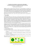
Coupling of artificial intelligence methods in the development of hybrid intelligent systems
In this paper we present an approach which couples various artificial intelligence (AI) methods in the solution of complex problems that cannot adequately be solved by a single AI method. We argue that the resulting, hybrid intelligent systems (HIS) can be successfully implemented with the use of available AI software libraries. Different coupling methods are analyzed and a classification of hybrid systems based on the chosen method is given. Two case studies of hybrid systems used in mining engineering ...hibridni inteligentni sistemi, spregnuti sistemi, metode veštačke inteligencije, rudarske primene veštačke inteligencije... analysis of area airpollution load GIS PollutNet AIRPRES Expert system for air pol lution analysis Data model NM-GA prediction Characterization of ECO domain CFD model - Meteorology - Airpollution - Topology Monitoring Fig. 3 Structure of a hybrid system for analysis of area air pollution ...
... presented: a system for planing and analysis of mine ventilation, as an example of intercommunicating hybrid systems, and a system for the analysis of area air pollution load, with characteristics of both function-replacing and intercommunicating hybrid systems. Key words: hybrid intelligent systems ...
... case-base reasoning, machine learning, neural networks or genetic algorithms have successfully been used for solving certain types of problems in a wide area of applications. However, each of these methods has both its advantages and its shortcomings, which makes it suitable for only a particular class ...Ranka Stanković, Ivan Obradović, Nikola Lilić. "Coupling of artificial intelligence methods in the development of hybrid intelligent systems" in X Kongres Matematičara, Matematički fakultet, Beograd (2001)
-

Numerical modeling of Selanac debris flow propagation using SPH code
The Selanac debris flow is a very huge event triggered after extreme rainfall caused by Cyclone Tamara activity in the Republic of Serbia in May 2014. The Selanac case study was already modelling in different programs using Voellmy rheology assumptions like RAMMS software. In this paper research are focusing particularly on the process of debris flowing from initiation zone to main deposition area using Geoflow SPH two-phase model considering frictional rheology law. Main rheological parameters are back-calculated using also ...... resolution is used as main topo file, with 133 452 points. Definition of the source area was made by comparing DTMs of different sequences (Krušić et al. 2019). Herein, a simulation with subtraction of release area, which has an influence on the movement of material, is appended. Selected rheology ...
... assumptions like RAMMS software. In this paper research are focusing particularly on the process of debris flowing from initiation zone to main deposition area using Geoflow SPH two-phase model considering frictional rheology law. Main rheological parameters are back-calculated using also Voellmy turbulent ...
... started to flow down the slope as a result of motion of solid and fluid phase. Different mechanisms, rheological and numerical models are used in this area of research. Generally, there are mainly two groups of models used for modeling on flow type landslides: empirical-statistical (Rickenmann, 1999 ...Jelka Krušić, Biljana Abolmasov, Miloš Marjanović, Manuel Pastor, Saeid M. Tayyebi . "Numerical modeling of Selanac debris flow propagation using SPH code" in SCG-XIII International Symposium on Landslides. Cartagena, Colombia- February 22-26, 2021, International Society for Soil Mechanics And Geotechnical Engineering (2021)
-
Determining seismic hazard in slowly deforming region: Can we gather enough information from karst caves?
Ana Mladenović, Jelena Ćalić (2021)Methods to determine seismic hazard in any region vary depending on the regional seismicity, but can be roughly grouped into two main groups: one based on probabilistic methods that use data about known seismicity in the region, and another, which is based on data related to the faulting processes and determination of seismically active faults. Both groups of methods are relatively good for seismically active regions. However, in regions of low seismic activity and slow deformations, there is neither ...Ana Mladenović, Jelena Ćalić. "Determining seismic hazard in slowly deforming region: Can we gather enough information from karst caves?" in EGU General Assembly 2021, European Geosciences Union (2021). https://doi.org/10.5194/egusphere-egu21-8723
-
Testing the energy value of different types of coal by the method of active thermography
In this paper, coal thermograms are presented and analyzed in order to determine their energy value. Two types of coal of different categories, brown and lignite, were selected for active thermographic imaging. The tested coal samples were processed before measurement so that they are similar in dimensions and have two plane-parallel smooth surfaces. The test samples were "primarily" heated under the same conditions and the process of their cooling was monitored by a thermal camera. "Then" they were cooled ...Stevan Đenadić, Ljubiša Tomić, Vesna Damnjanović, Predrag Jovančić, Dragutin Jovković. "Testing the energy value of different types of coal by the method of active thermography" in 9th International Scientific Conference on Defensive Technologies, Belgrade, Serbia, 15-16 October 2020, The Military Technical Institute (2020)
-
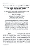
Age and microfacies of oceanic Upper Triassic radiolarite components from the Middle Jurassic ophiolitic mélange in the Zlatibor Mountains (Inner Dinarides, Serbia) and their provenance
Hans-Juergen Gawlick, Nevenka Đerić, Sigrid Missoni, Nikita Bragin, Milan Sudar, Divna Jovanović (2017)Neo-Tethys, trench-like basins, synorogenic deposition, evolving thrust belt, Triassic palaeogeography... Geographical sketch map showing the study area (marked by an asterisk) of the ophiolitic mćlange between Trnava and Rožanstvo in southwest Serbia. b — Modified geological map ofthe Geological map ofthe Republic of Serbia, Užice 4, 1:50,000 and Missoni et al. (2012) (area between Trnava, Sirogojno and Rožanstvo ...
... ophiolites + + B oceanic crusUoophiolites position of the study area c Callovian/Early Oxfordian ongoing westward directed (~163-160 Ma) ophiolite obduction ? « -o —oC—o— J iddle - position of the P Micdle - Late study area' future DOB TIII "plagiogranites" formation of SSZ BBB ceanic ...
... derived from the advan- cing ophiolite nappe stack in the area where the Sirogojno carbonate-clastic mćlange was formed filled in the first stage of deposition the remaining topography of the older basin fill (Figs. 9, 10c), but still in an area ecast ofthe Drina-Ivanjica unit. The final emplacement ...Hans-Juergen Gawlick, Nevenka Đerić, Sigrid Missoni, Nikita Bragin, Milan Sudar, Divna Jovanović. "Age and microfacies of oceanic Upper Triassic radiolarite components from the Middle Jurassic ophiolitic mélange in the Zlatibor Mountains (Inner Dinarides, Serbia) and their provenance" in Geologica Carpathica (2017)
-
Горњокредне творевине северозападне Србије
Bojan M. Glavaš-Trbić (2013-11-26)У раду су приказане палеогеографске карактеристике и геотектонски положајширег подручја (Јадарског блока и Вардарске зоне) које су утицале на условеталожења, односно карактеристике горњокредних творевина на простору данашњесеверозападне Србије.Описани су карактеристични локални геолошки стубови уз приказ њиховихлитолошких, биостратиграфских и седиментолошких карактеристика. При томе сукоришћена досадашња сазнања о предметном простору изложена у домаћим радовима,и извршена је компарација и корелација са подацима суседних терена, ширеперитетиског ареала.Истраживања у првој фази су вршена на међусобно удаљеним и релативномалим профилима – често само ерозионим крпама ...Bojan M. Glavaš-Trbić. "Горњокредне творевине северозападне Србије" in Универзитет у Београду, Универзитет у Београду, Рударско-геолошки факултет (2013-11-26)
-
Joint interpretation of paleomagnetic, structural and AMS results from the Vardar Zone of Serbia
Emo Marton, Marinko Toljić, Vesna Lesić, Vesna Cvetkov. "Joint interpretation of paleomagnetic, structural and AMS results from the Vardar Zone of Serbia" in 18th Meeting of the Central European Tectonic Studies Group (CETEG) & 25th Meeting of the Czech Tectonic Studies Group, 22-25th April, 2021, Terchová, Slovakia, Department of Geological Sciences, Masaryk University in cooperation with the Czech Geological Survey, IPE MU Brno and UK Praha (2021)
-
Defining structural correlation using of total horizontal gradient
Gravity data can help to define the structural correlation along significant vertical shifts. The different procedures of mathematical transformations on gravity data are applied to define structural correlations. The paper presents the results obtained using the procedure total horizontal gradient on gravity data. The application of the total horizontal gradient helped to detect contacts with a large dip angle (vertical or subvertical contacts), which can be interpreted as faults. The study area located in the wider area of the ...Snežana Ignjatović, Ivana Vasiljević, Milanka Negovanović. "Defining structural correlation using of total horizontal gradient" in The 52nd International October Conference on Mining and Metallurgy, Bor, novembar 29-30.11.2021., University of Belgrade ‐ Technical faculty in Bor, Bor, November 2021 (2021)
-

Determining seismic hazard in slowly deforming region: Can we gather enough information from karst caves?
Ана Младеновић, Јелена Ћалић (2021)... faults. Because ofthat, all sets of data have to be combined in order to gather necessary information needed todetermine seismic hazard for a given area. One of such regions of low seismicity and very slow deformation is the region of Carpatho-Balkanorogen, situated in Eastern Serbia. This orogen represents ...
... . Samples for radiometric dating have been collected, that will help to quantify fault activity rate. Preliminary results show that the research area is characterized by strike-slip tectonics, most likelyresulting from far-field stress generated by the collision of the Adriatic microplate, the Mo ...
... Moesianindenter and the tectonic units in-between. Such stress field is shown to be highly heterogeneouseven in this relatively small research area, so local areas of transtension and transpression havealso been very important in controlling the recent fault kinematics in this part of the Carpatho-Balkanides ...Ана Младеновић, Јелена Ћалић. "Determining seismic hazard in slowly deforming region: Can we gather enough information from karst caves?" in EGU General Assembly 2021, European Geosciences Union (2021). https://doi.org/10.5194/egusphere-egu21-8723
-
Back-arc underplating provided crustal accretion affecting topography and sedimentation in the Adria microplate
Paolo Mancinelli, Vittorio Scisciani, Cristina Pauselli, Gérard M. Stampfli, Fabio Speranza, Ivana Vasiljević (2021)Supported by evidence of deep crustal sources for the observed magnetic anomalies in Central Italy and by outcropping gabbros in the Croatian archipelago, we model the observed gravity and magnetic anomalies in the Central Adriatic Sea and surroundings. We suggest that the major magnetic anomalies in the area are related to a wide underplating and propose that this volume represents the first stage of the back-arc Adria continental breakup in Early Permian times. During the Palaeotethys-Adria collision, underplating has ...Paolo Mancinelli, Vittorio Scisciani, Cristina Pauselli, Gérard M. Stampfli, Fabio Speranza, Ivana Vasiljević. "Back-arc underplating provided crustal accretion affecting topography and sedimentation in the Adria microplate" in Marine and Petroleum Geology, Elsevier Ltd. (2021). https://doi.org/10.1016/j.marpetgeo.2021.105470
-
Heavy metals in lignite and soil of Kostolac-Kovin coal basin, eastern Serbia - comparative analysis with selected cities in Serbia, region, Europe and world
Bogoljub Vučković, Bojan Dimitrijević (2023)The Kostolac-Kovin coal basin with an area of 320 km2, with 5 separate layers of coal and with a total of about 5.7 Bt of geological resources and reserves represents an exceptional potential for coal production in Serbia. The coal resources listed in this way are not fully exploitable, but they represent potential for consideration. In this paper, we deal with the geochemical characteristics of coal seams and perform a comparative analysis of coal affectation on the environment. With ...... concluded that there is a certain lateral zonation of the distribution of Zn, Cu and Pb (ppm) in such a way that in the area of the Drmno deposits there are lower, and in the area of West Kostolac and Kovin, elevated HM values (Figure 4). | Coal Layer Zn avg. = 35 ppm Kovin 2 / Open Pit Drmno ...
... Mining and Geology, Belgrade, Serbia bogoljub.vuckovic(a)eps.rs, bojan dimitrijevic(Q0)rgf.bg.ac.rs 4bstract:The Kostolac-Kovin coal basin with an area of 320 km?, with 5 separate layers of coal and with a total of about 5.7 Bt of geological resources and reserves represents an exceptional potential ...
... GENERAL INFORMATIONS The coal basin is located in castern Serbia, between the Velika Morava and Mlava rivers, which flow into the Danube in that area (figure 1 and 2). Itis divided into two parts by the Danube - to the south is the Kostolac Basin, and to the north ofthe Danube is the Kovin Basin ...Bogoljub Vučković, Bojan Dimitrijević. "Heavy metals in lignite and soil of Kostolac-Kovin coal basin, eastern Serbia - comparative analysis with selected cities in Serbia, region, Europe and world" in 9th International Conference Mining and Environmental Protection, 24–27. May 2023, Sokobanja, Beograd : Univerzitet u Beogradu, Rudarsko-geološki fakultet (2023)
-
Permanent GNSS monitoring of landslide Umka
Mileva Samardžić Petrović, Jovan Popović, Uroš Đurić, Biljana Abolmasov, Marko Pejić, Miloš Marjanović (2020)Клизиште Умка је једно од највећих насељених активних клизишта у Србији. Активност клизишта Умка се прати већ више од 85 година, различитим геотехничким и геодетским техникама. Од 2010. године, активност kлизишта се континуирано прати у реалном времену аутоматизованим перманентним системом за праћење базираним на Глобалним навигационим сателитским системима (ГНСС). Поред тога, од 2018. године активност клизишта се додатно прати кинематичким ГНСС одређивањем положаја скупа карактеристичних тачака као и применом UAV фотограметрије. Главни циљ овог рада је приказ резултата опажања три ...... landslide area in relation to the three-surrounding stable GNSS permanent stations of the national GNSS service, AGROS; 2. Monitoring of the position change for the set of characteristic points on the landslide area, in relation to the set of stable points surrounding the landslide area, using GNSS ...
... analyze the Umka landslide dynamic, in March 2018, a passive GNSS network consisting of four stable points surrounding landslide area is realized. The landslide area is discretised by 62 properly stabilized characteristic points. Between March 2018 and April 2019, three observation epochs were ...
... assess the dynamics of the landslide phenomenon and potentially prevent possible disasters [1-5]. Considering the importance of the Umka urban area permanent monitoring, automated GNSS monitoring system was established in March 2010. This was a part of the technological development project “The ...Mileva Samardžić Petrović, Jovan Popović, Uroš Đurić, Biljana Abolmasov, Marko Pejić, Miloš Marjanović. "Permanent GNSS monitoring of landslide Umka" in International Conference on Contemporary Theory and Practice in Construction XIV Stepgrad, University of Banja Luka, Faculty of Architecture, Civil Engineering and Geodesy (2020). https://doi.org/10.7251/STP2014091S